Who are GeoPlace
GeoPlace are responsible for managing Great Britain’s definitive, national database of addresses and streets. The team is proud to have a reputation for excellence in managing address and street data.
By law, local authorities in England and Wales must give every property in their area an individual, authoritative address. Royal Mail then assign their official postcode and post town to this.
GeoPlace supports Britain’s local authorities as they create and manage information about those addresses. We act as the co-ordinator, validating and collating the data as it comes in, before passing it on to Ordnance Survey (OS) who make it available through their AddressBase® range of products.
Further information can be found on the GeoPlace website.
Why FindMyAddress has been created
Working on behalf of local authorities, GeoPlace has created FindMyAddress to provide a central point for queries on open Unique Property Reference Numbers (UPRNs). It’s a partnership with OS and the Local Government Association (LGA).
In recognising the importance of UPRNs, via the Government Digital Service (GDS), the UK Government has now mandated the use of UPRNs as the standard way of referencing and sharing information about properties across government. This will help to improve services for citizens, reduce costs, and improve the efficiency and effectiveness of data sharing in many ways.
For example; it can identify better waste collection routes; ensure more accurate quotes for insurance; help speed up the conveyancing process and make fraud detection easier.
UPRNs are the standard way of referencing every property. The open dataset provides the UPRN and its geographic co-ordinates, while FindMyAddress enables anyone to search for and view their official address, UPRN and location.
The underlying data is created and maintained by local authorities. It’s collected and managed centrally by GeoPlace and then published by Ordnance Survey as AddressBase®.
FindMyAddress is for personal, non-commercial use only. Users can perform up to 10 searches every day, free of charge. Need more searches?
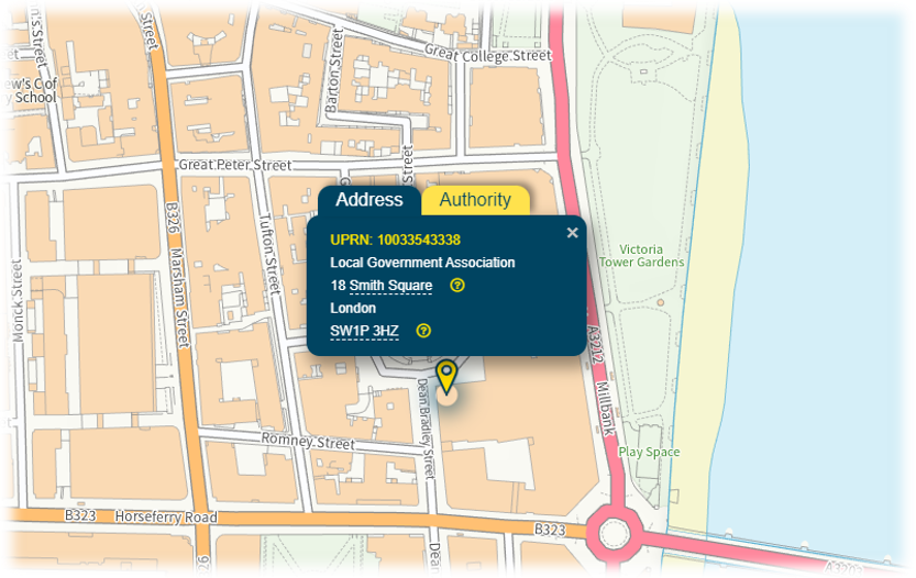
Unique Property Reference Numbers (UPRNs)
A UPRN is a unique number for every addressable location. In the same way people have National Insurance numbers, or cars have vehicle registration numbers, these codes are used to identify unique physical locations and objects in Great Britain.
Every UPRN is different. Each one is linked to the same object for the whole of that object’s life, they can be assigned from the planning stage and are never reallocated. Each UPRN has a National Grid Co-ordinate to locate it on a map.
Individual flats within a block will also have their own UPRN. This makes the UPRN essential for emergency services, local authorities and any organisation or individual needing to pin-point the precise location of a property including energy and utility providers, online shopping websites and delivery companies.
Because it never changes, the UPRN is a highly valued asset. A UPRN guarantees which property or object is being identified. A UPRN also makes it possible to identify a property without needing to use personal data – the names and details of any people living there.
In addition, as a machine-readable code, it is easy to share and use a UPRN in any kind of dataset – which also makes it easier for organisations using different data to link those datasets, confidently knowing they're all identifying the same property.
Find out more about UPRNs in our blog ‘So what are these UPRNs and USRNs that everyone is talking about?’
The importance of good address data
Good addressing makes life easier. Think about deliveries, insurance, the emergency services, credit cards and bank accounts, energy, broadband, and all local government services.
Good addressing enables organisations to work closely with each other, keeping records up to date and making sure their services are delivered efficiently and securely. It also makes it possible to find our way around, whether that’s using a smartphone, a website, or a map.
Above all, accurate addressing is essential for the emergency services where location-based information and journey times really can be a matter of life or death.
In Great Britain, most of these services depend on the information that is produced by local authorities, managed by GeoPlace and made available as products by Ordnance Survey.
Excellent addressing has the power to transform people’s lives. GeoPlace is the guardian and champion of that information on a national scale.
You can find more detailed information about us on our main website.